Living with Water | Utile, Inc.")
Honorable Mention | Urban Design (Concept)
Firm Name: Utile, Inc.
Participant Name: Kara McLellan
Team Member: Kara McLellan, Elizabeth Christoforetti
Country : United States

For centuries, Boston has been sculpting its shoreline and landmass for densification and economic expansion. We see the response to sea level rise as an opportunity to resume fundamental activities of city-building. Faced with this dilemma in the 19th century, we would simply add more fill, and bury or demolish existing structures. Today, we face a more mature and complex urban fabric with historical buildings, diverse and evolving land use patterns and property ownership, precluding traditional engineering solutions. To escape the rising tide, we need a “21st century” strategy, which creates a long-term planning framework accommodating the GRADUAL evolution of a new, elevated street and access network, and allows the current grade to adapt from a functional access level to an increasingly wet, ecologically diverse open space asset. Our approach is conceived as two ground planes, built in phases, and changing in function as development and sea level rise occur.
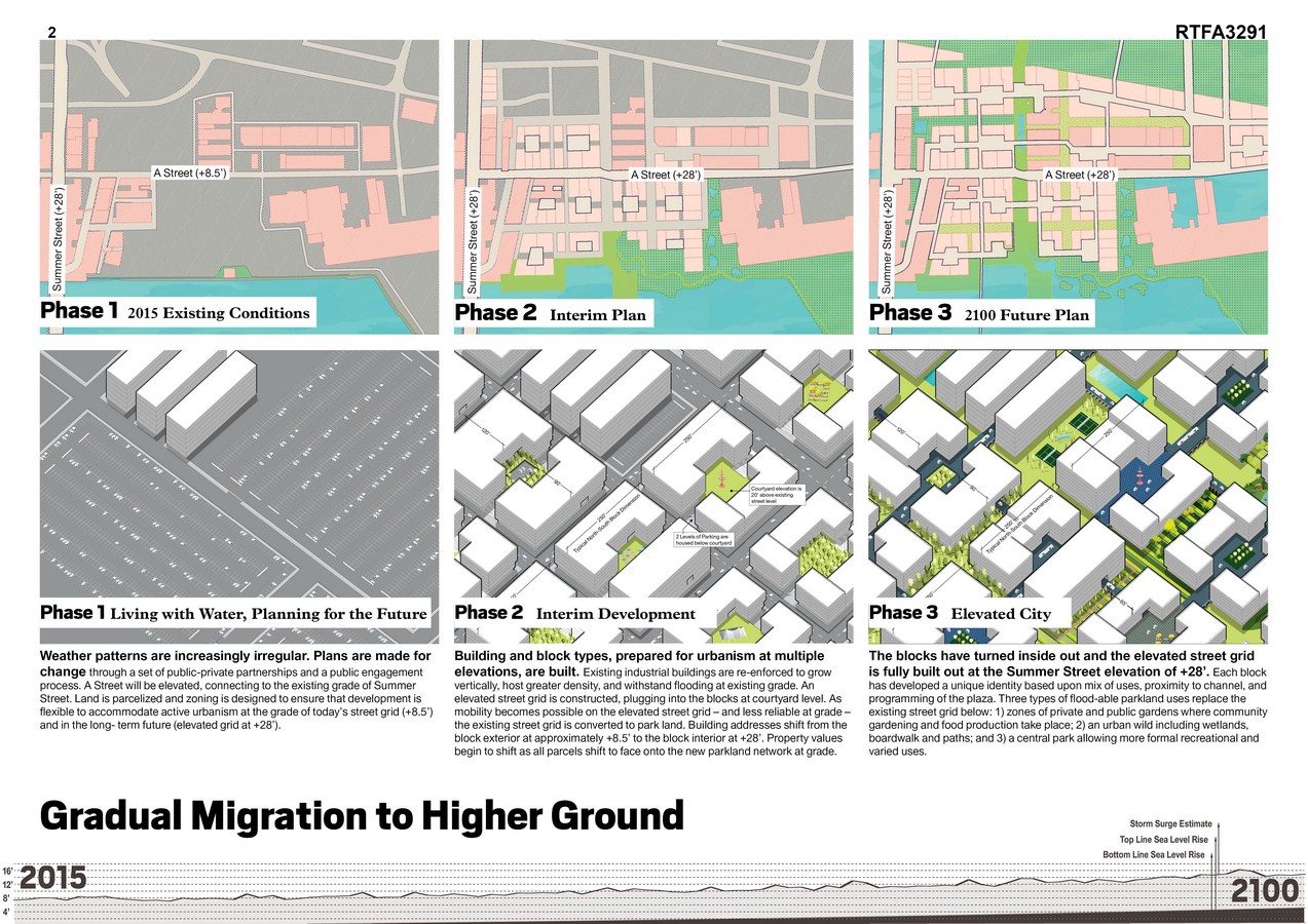
Base Level: Existing grade, typically +8.5’, continues to provide a functional ground plane for the near-term, including primary building access, parking, and waterfront access. As flooding increases, this level transitions to open space “greenways”, graded with displaced fill from new development, creating a variety of ecologically-adaptable habitats and recreational landscapes.
Podium Level: Typically +28’, a network of elevated access roads build off the existing elevation of Summer Street, originally raised to span over rail lines to the east. Beginning at the intersection of Summer and A Streets, the Podium Level network will gradually advance south along A, then east and west as development occurs.
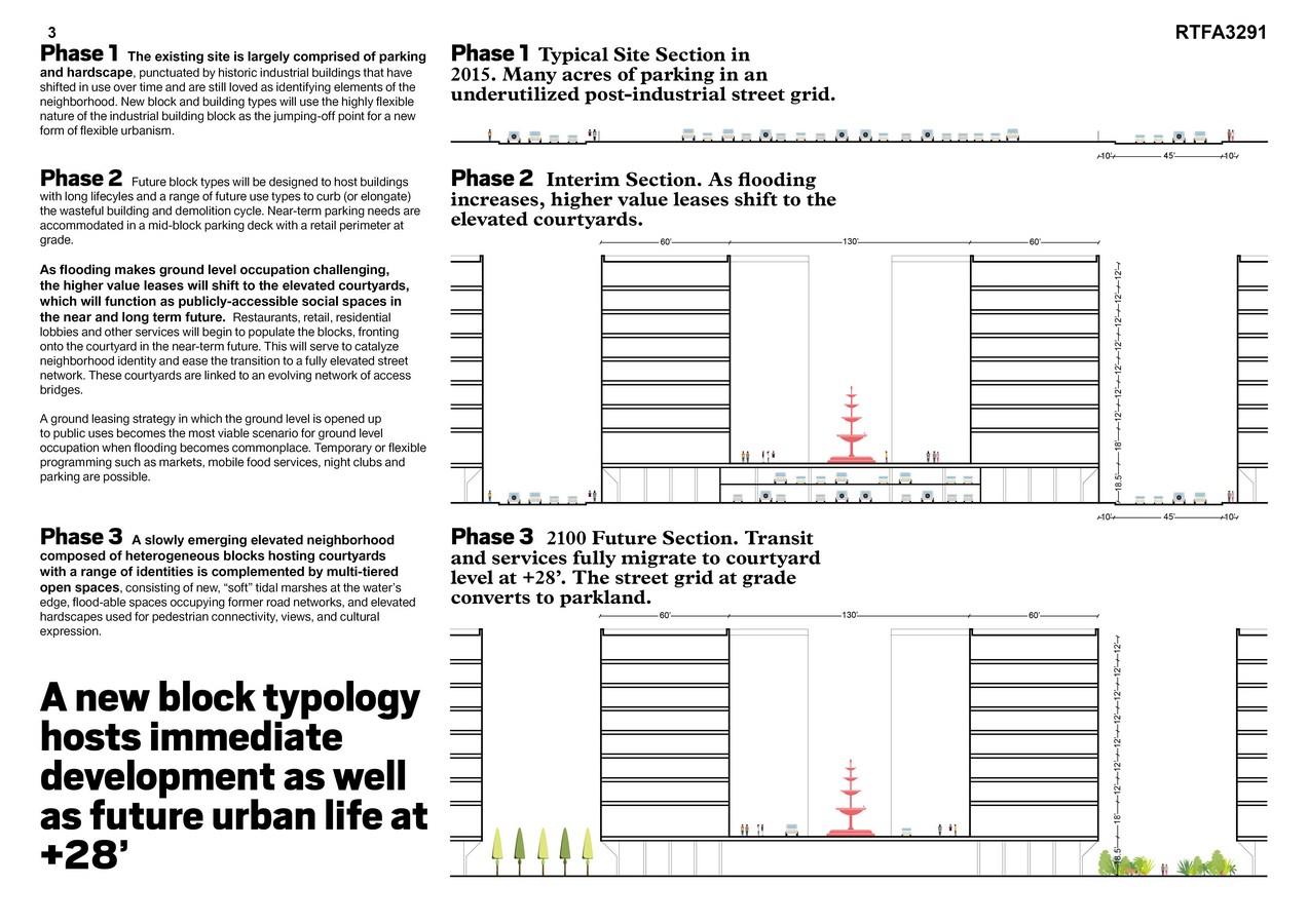
The approach is opportunistic; new infrastructure shouldn’t merely protect existing and future assets, but should catalyze adaptable and beautiful neighborhoods designed with responsive vegetated systems and innovative block and streetscape types. To accommodate near-term flooding, the plan is broken into a series of blocks internalized as courtyards, which can be raised and linked to an evolving network of access bridges. This slowly-emerging elevated neighborhood is complemented by multi-tiered open spaces, consisting of new, “soft” tidal marshes at the water’s edge, floodable spaces occupying former road networks, and elevated hardscapes used for pedestrian connectivity and cultural expression. Just as the elevated A Street, “High Street,” provides a primary armature for street connectivity and development (“High Spine”), a main central axis of potentially floodable parks becomes the landscape backbone of the masterplan development, allowing connections within a general pattern of potentially floodable public greens.

Balancing public and private investment in development is essential to success. Proximity to water needs to be leveraged into an asset rather than a liability, so public investment in infrastructure is matched by increases in taxable private property. As the channel is increasingly de-industrialized, open spaces will become more valuable to abutting properties. Our assumption is that the incremental cost of multi-leveled access is more than offset by prime waterfront access, proximity to the region’s largest public transportation hub, and downtown. Our solution is specific to the particular urban morphology of this district, but also adaptable to low-lying coastal industrial districts in any city.
If you’ve missed participating in this award, don’t worry. RTF’s next series of Awards for Excellence in Architecture & Design – is open for Registration.
Click Here